
 SAINT GOBAIN 85.440 € (+0,85 %) AMUNDI 96.750 € (-0,36 %) SANOFI 75.310 € (+1,35 %) COFACE 16.100 € (-0,19 %)
  TOMTOM 4.042 € (+1,56 %)
  X-FAB 7.030 € (+3,84 %)
  MAROC TELECOM 9.000 € (+0,22 %) UMG 15.565 € (+2,71 %) SOITEC 122.500 € (+1,45 %) PHILIPS KON 23.130 € (+0,70 %)
  UNILEVER 54.650 € (-0,78 %) ATOS GROUP 31.700 € (-0,13 %) CARVOLIX 6.200 € (-1,90 %) ENERGY SOLAR 1.400 € (+1,08 %) MEDINCELL 24.500 € (-1,69 %) AALBERTS NV 45.080 € (+0,54 %) L'OREAL 385.900 € (-1,15 %) S.E.B. 59.500 € (-0,67 %) BONDUELLE 8.610 € (-1,37 %) LUMIBIRD 27.000 € (+1,50 %) ADYEN 930.300 € (-0,31 %) PEUGEOT INVEST 57.500 € (+0,35 %) LAKEFRONT BIOTHER. 23.340 € (+3,83 %) LVMH 480.000 € (-0,30 %) ENGIE 26.720 € (+0,60 %) CSG 17.714 € (-8,02 %) ABN AMRO BANK N.V. 39.730 € (-0,13 %) SBM OFFSHORE 32.400 € (-7,69 %) BUREAU VERITAS 28.360 € (-0,28 %) AB SCIENCE 1.000 € (+24,07 %) KERING 286.650 € (-1,07 %) BOUYGUES 48.640 € (-1,12 %) AKZO NOBEL 63.520 € (-0,06 %) NANOBIOTIX 33.460 € (+0,78 %) HEINEKEN 77.140 € (-0,87 %) ALTAREA 100.400 € (-0,20 %) RUBIS 33.400 € (+0,30 %) REMY COINTREAU 46.600 € (+2,69 %) KAUFMAN ET BROAD 25.250 € (+0,60 %) TELEPERFORMANCE 70.000 € (+1,92 %) HAFFNER ENERGY 0.456 € (-1,19 %) SHELL PLC 38.390 € (-1,01 %) 2CRSI 27.600 € (-0,79 %) LISI 67.200 € (+1,66 %) TRIGANO 152.900 € (+1,12 %) V LANSCHOT KEMPEN 65.250 € (-0,76 %) TIKEHAU CAPITAL 17.020 € (+0,59 %) HEINEKEN HOLDING 72.650 € (-1,29 %) Coca-ColaEuropacif 92.900 € (-1,06 %) UNIFY GROUP 1.862 € (-0,53 %) POSTNL 0.911 € (-2,57 %) ASML HOLDING 1 499.000 € (+0,33 %) PHARMING GROUP 0.960 € (+1,52 %) EXAIL TECHNOLOGIES 124.600 € (+0,08 %) VETOQUINOL 72.600 € (+1,82 %) CTP 14.680 € (-3,17 %) TOTALENERGIES 74.090 € (-0,60 %) CROSSJECT 1.498 € (-1,45 %) RELX 30.840 € (+1,05 %) VEOLIA ENVIRON. 35.190 € (+0,34 %)
 |
29/06/2026 09:01
HM Exploration Discovers New Blind Massive Sulphide Lens at Lewis Pilley's ProjectVANCOUVER, BC / ACCESS Newswire / June 29, 2026 / HM Exploration Corp. ("HM Exploration", "HM" or the "Company") (CSE:HM)(FSE:X5H)(OTCQB:HMEXF) is pleased to announce that it has completed an additional three holes as part of the phase one drilling program (the "Program") at the Company's Lewis Pilley's Project (the "Project"), located in Newfoundland, Canada. 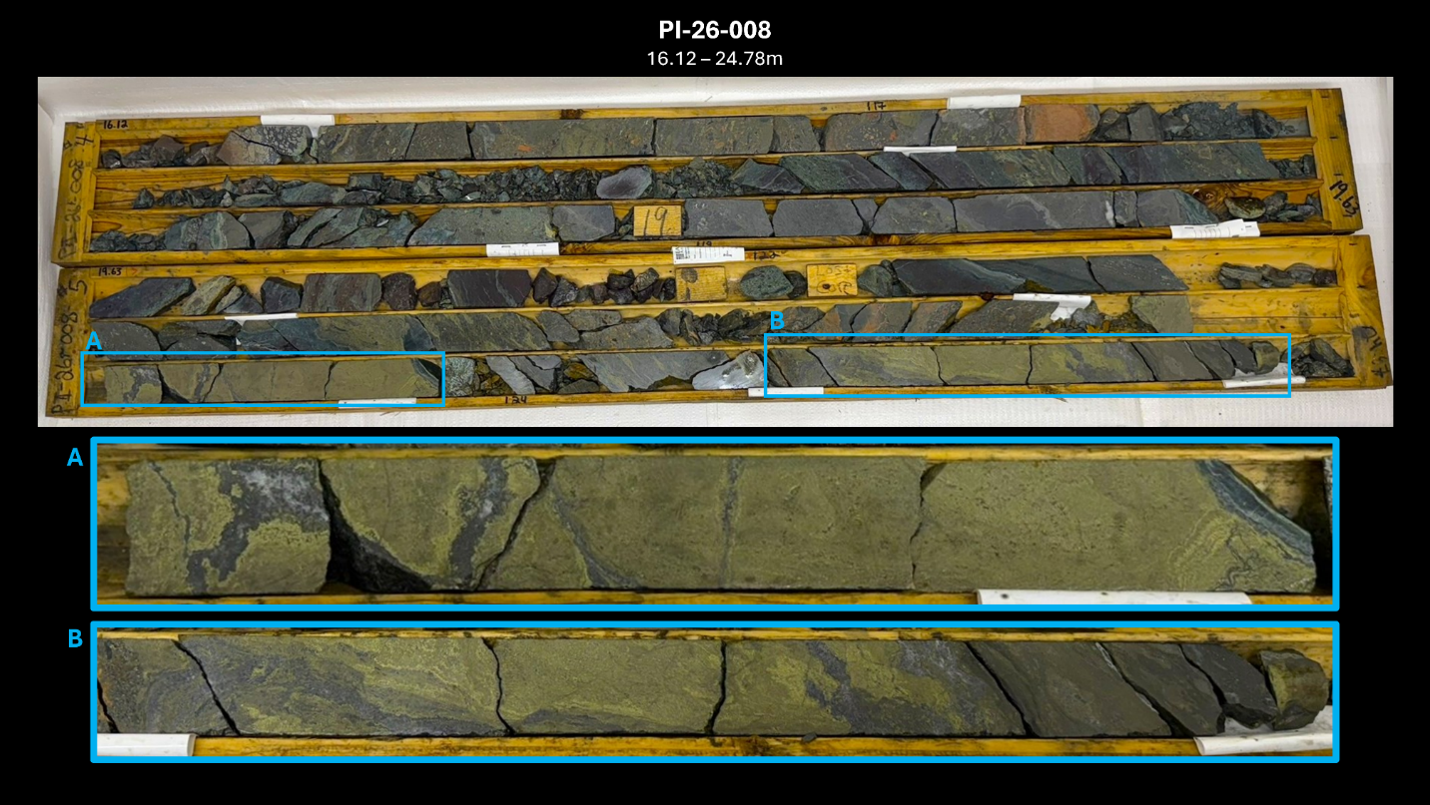 The three holes in this press release represent an additional 544.27 metres for a total drilled meterage of 1,632.27m of a planned minimum 2,500 metres of diamond drilling. Highlights:
"While we were expecting to see significant mineralization below the exposed massive sulphide horizon at the Clifford Jones trench, the intersection of the lower-lens came as a welcomed new exciting discovery" said Nick Ryan, Chief Geologist with HM Exploration Corp. "The discovery of a second mineralized lens demonstrates that the system is more extensive than previously recognized and supports the potential for multiple stacked sulphide horizons. We look forward to receiving laboratory assays back and delineating the extents of this new discovery with subsequent drilling." Drilling was focused on evaluating the continuity of the mineralized system below known surface showings and along strike of Clifford Jones Zone (the "Zone") to improve the Company's understanding of the geological controls on mineralization (Figure 2). Visual observations from drilled holes indicate that the upper targeted copper-bearing debris flow was successfully intersected, with zones of alteration and massive to semi-massive sulphide mineralization observed in the drill core. Drill holes 7 and 8 have successfully intersected a new lower mineralized sulphide lens that was previously undiscovered. The lower-lens appears more massive indicating that the geometry of this lens may assist with vectoring towards the source vent(s) as depicted in Figure 3. Core samples have been submitted to the laboratory for analysis. Assay results will be released once they have been returned to the Company. All three holes from this release intersected a wide range of massive, semi-massive and disseminated sulphide mineralization over the following drill core lengths*:
Mineralization can be described as clast-dominated debris zones consisting of sub-angular to angular fragments of massive sulphide (~85% of intercept) composed of Cpy + Py ± Sph ± Gn suspended in interstitial fine-grained disseminated sulphides (Py + Cpy ± Sph ± Gn) and milled felsic ± mafic rock. Matrix-dominated debris flow composed of fragments of sub-rounded to angular clasts of massive sulphide (Py + Cpy ± Sph ± Gn) and felsic ± mafic lithic fragments suspended in a matrix of fine-grained sulphide (Py + Cpy ± Sph ± Gn) and milled felsic ± mafic rock. More detailed classifications for individual intercepts are referenced in Table 2 below*. * The Company cautions that the presence of visible sulphides and visual estimates of mineral abundance are not indicative of grade and should not be considered a substitute for laboratory analysis. Assay results are pending. 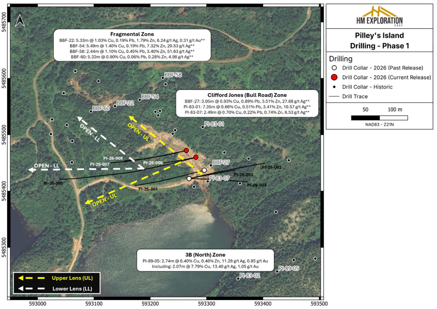 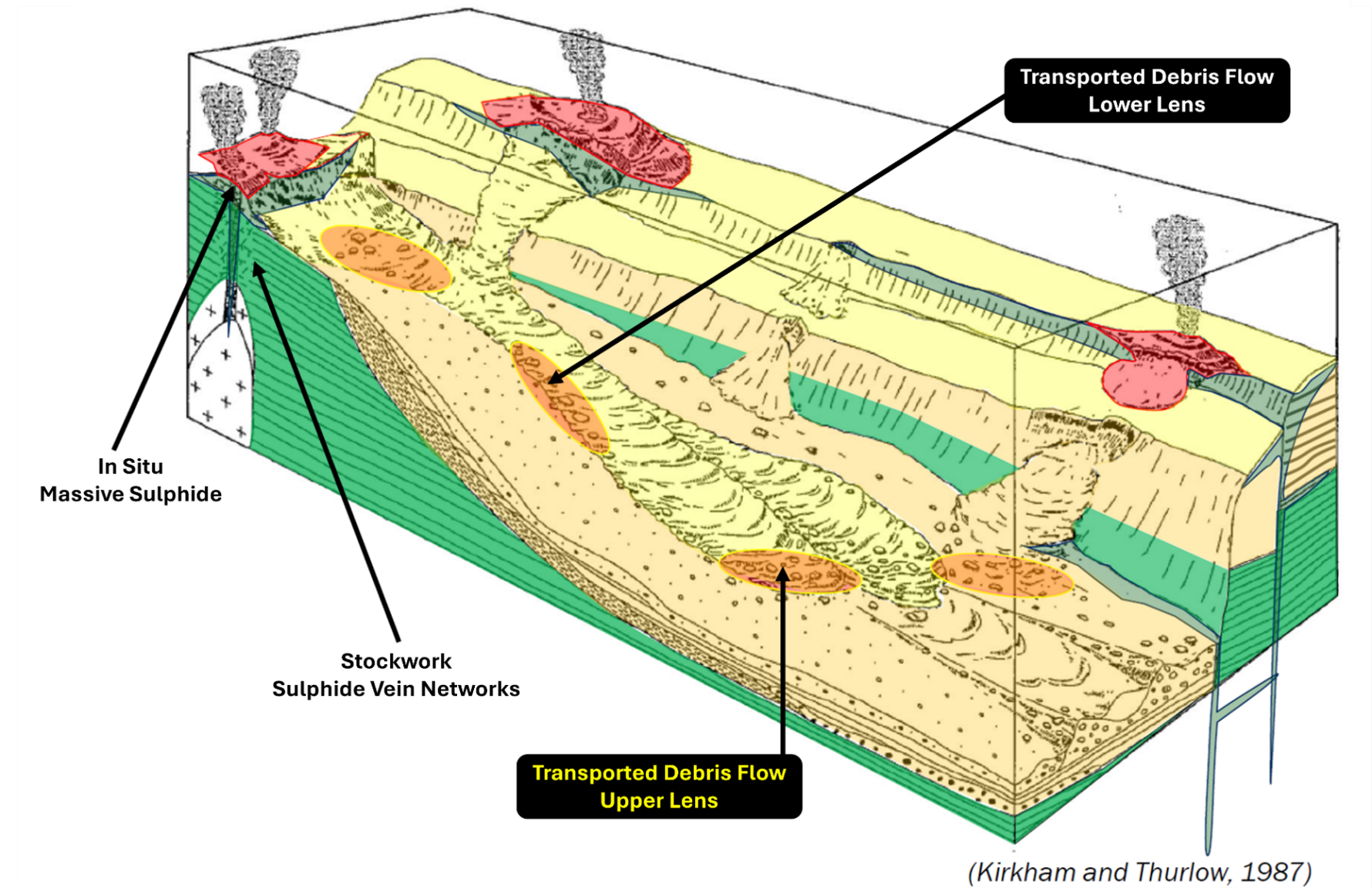 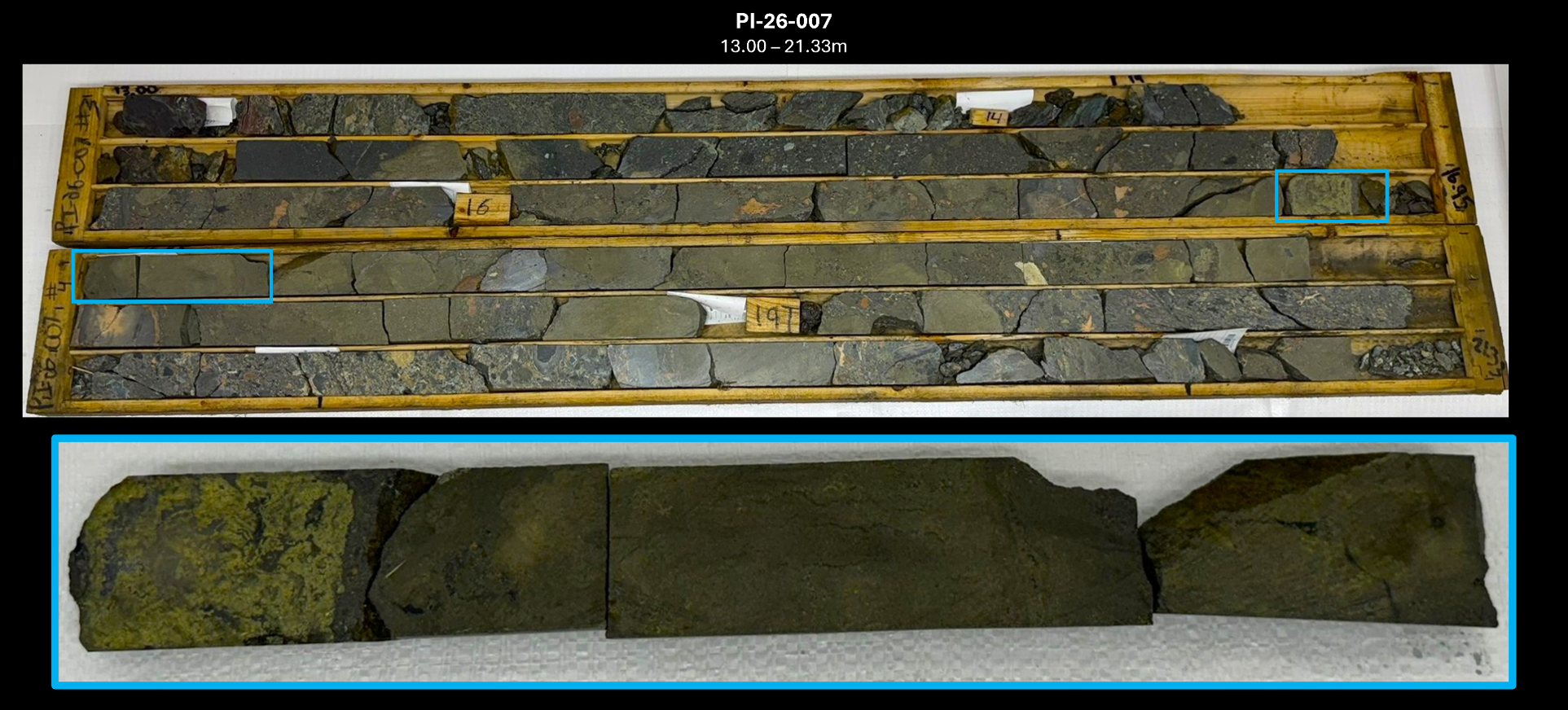 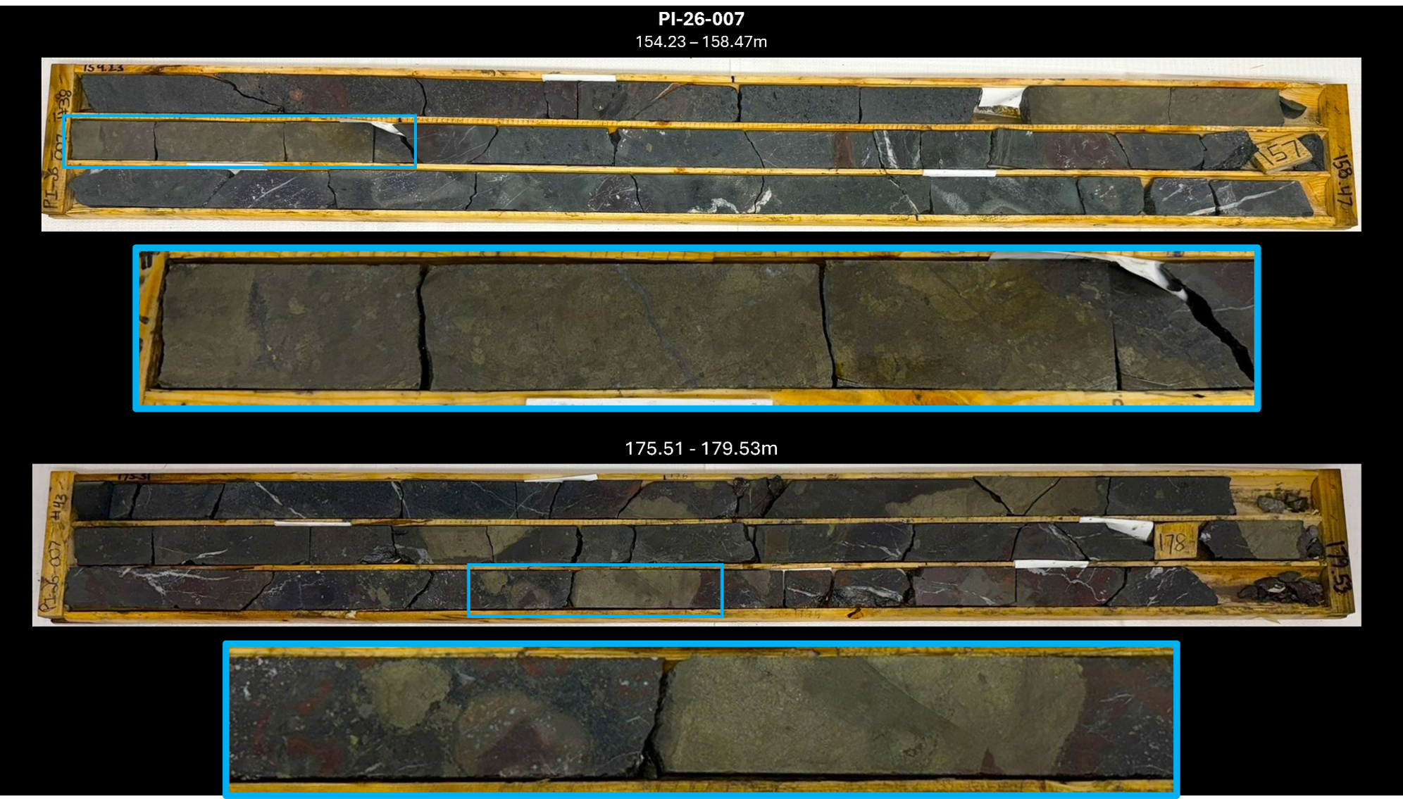 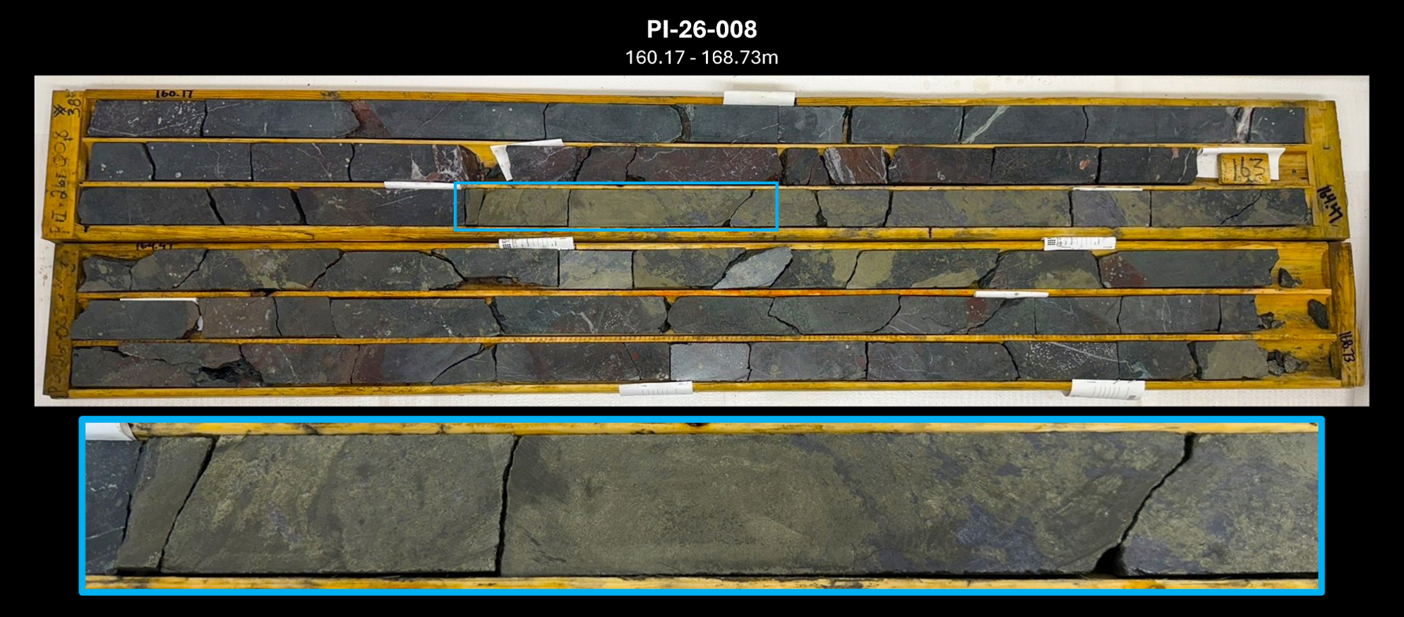 Table 1: 2026 drill collar data; Coordinates reported in NAD83 - Zone 21N.
Table 2: Mineralized interval descriptions.
Geology & Mineralization The Project is located within the Notre Dame Subzone of the Dunnage Tectonostratigraphic Zone. Of note, most of the Project is underlain by Ordovician submarine volcanic rocks of the Roberts Arm Group which is regionally identified as part of a mature arc sequence referred to as the Buchans-Roberts Arm Belt that also hosts the historic Buchans mine (after Dunning et Al., 1987). Mineralization occurs as lower grade (Spencer's Dock); medium grade (Old Mines); and high grade (3B-Zone/Clifford Jones) deposits that are of both sub-seafloor replacement and exhalative varieties. The deposits are often flanked by extensive chlorite, sericite, silica, K-feldspar and epidote alteration often observed in bimodal-felsic VMS systems. The Spencer's Dock area displays sericite/silica alteration that generally increases in intensity near mineralized zones, while the 3B/Old Mine areas display sericite/silica alteration that is abundant but less widespread and is more intense when proximal to mineralized zones (after Kerr, 1996). VMS deposits are a globally significant source of copper, zinc, lead, silver, and gold. The Project's geology shares key characteristics with known Volcanogenic Massive Sulphide ("VMS") districts in Newfoundland, including the past producing Buchans, Ming and Rambler Mines, supporting the exploration potential of the Project. About Lewis Pilley's Project The Project is road accessible and situated approximately twenty-five (25) km east of the town of Springdale, approximately fifty-five (55) km southeast of Firefly Metals' Green Bay Project and approximately one hundred fifty (150) km from the Pine Cove Mill and Port by way of major roads (Figure 7). The Project has a long history of mining and exploration dating back to the late 1800s when the Pilley's Island Pyrite Company Ltd. produced approximately 450,000 tonnes of massive pyritic ore from the Pilley's Island Mine-Old Mines (after Kerr, 1996). The Project hosts a cluster of VMS systems and prospects with demonstrated high-grade Zn-Pb-Cu-Ag+/-Au intersections. Mineralization is typical bimodal-felsic VMS, with both massive sulphide and sulphide-clast breccias (Thurlow, 1996). The geological setting is directly analogous to the Buchans camp (Thurlow, 1996), and the presence of sulphide-clast breccias is a strong vector toward proximal massive sulphide lens. Most of the historic showings that fall within the extents of the Project have not seen systematic exploration. Many of the historic drill holes were shallow and drilled in a vertical orientation limiting the geological knowledge of the extents of the underlying lithology and mineralization. Work is being planned to validate historic assay results as well as collect new data from the 3B-Zone, Clifford Jones (Bull Road) Extension, Bouzanne Shaft, Henderson, Mansfield and Pilley's Cove Showings.  Sampling, Preparation & QA/QC Drill collar locations were determined from hand-held GPS (NAD83-Zone 21N) and the drill rig was aligned using a Reflex TN-14 Gyrocompass alignment tool. All samples are given a unique sample ID and number and shipped directly to Eastern Analytical Ltd. (403 Little Bay Road, Springdale, NL), a commercial laboratory that is ISO/IEC 17025 accredited and completely independent of the company. Analytical methods include ICP-OES (34 element) with four-acid digestion, Au Fire Assay (30g) with AA finish, and Ore Grade Assay (multi-acid digestion) with AA finish. The Company inserts standard, blank, and duplicate samples as part of its standard QA/QC procedures. National Instrument 43-101 Disclosure Nicholas Rodway, P.Geo, (Licence# 46541) (Permit to Practice# 1000359) is CEO and Director of the Company, and a qualified person as defined by National Instrument 43-101- Standards of Disclosure for Mineral Projects. Mr. Rodway has supervised the preparation, verified and approved the technical content in this news release. Verification included review of drill logs, sample tags, chain of custody procedures and analytical protocols. No limitations were noted during the verification process. References Dunning, G.R., Kean, B.F., Thurlow, J.G and Swinden, H.S. (1987): Geochronology of the Buchans, Roberts Arm and Victoria Lake Groups and Mansfield Cove Complex, Newfoundland. Canadian Journal of Earth Sciences, Volume 24, pages 1175-1184. About HM Exploration Corp. The Company is currently advancing its Lewis Pilley's Project located in Newfoundland. The Project encompasses a land area of ~60.25 km² and hosts a cluster of volcanogenic massive sulphide (VMS) systems and the historic Pilley's Island Mine (~450,000 tonnes of ore produced in the late 1800s). Historic drilling at the 3B-Zone returned significant intersections, including 16.77m of 1.84% Cu and 3.05m of 5.03% Zn with 1.02 g/t Au (Au Pell, 1989). The geological setting is directly analogous to the prolific Buchans camp, with multiple underexplored showings and strong potential for new discoveries. In addition, the Company holds 100% interest in the Devil's Den Project, an exploration-stage Project consisting of two contiguous mineral licences encompassing ~3,200 hectares located west of Port Alberni, Vancouver Island, British Columbia. Exploration work completed in 2022 established four geochemical Source : Webdisclosure.com |
Cotations différées d'au moins 15 minutes (Paris, Amsterdam, Bruxelles, Lisbonne).
Cotations à la clôture (Francfort, New-York, Londres, Zurich).
Flux de cotations : Euronext (Places Euronext et Cours des Devises).
Bourse : technologie Cote Boursière