
 HAVAS 18.400 € (0,00 %)
  VIRIDIEN 84.550 € (+0,59 %) STIF 50.400 € (-4,55 %) PLANISWARE 20.100 € (+0,25 %) EXOSENS 62.400 € (+0,73 %) AYVENS 11.460 € (-4,50 %) EUROFINS SCIENT. 67.140 € (-4,87 %) ADYEN 815.600 € (-0,65 %) EIFFAGE 122.100 € (-0,53 %) MICHELIN 34.980 € (-0,09 %)
  SHELL PLC 39.155 € (+1,29 %) ABIONYX PHARMA 1.910 € (-0,52 %) UMG 18.155 € (-1,01 %) BNP PARIBAS ACT.A 105.380 € (-1,31 %) EURONEXT 147.000 € (-0,47 %) STMICROELECTRONICS 49.685 € (-14,73 %) CREDIT AGRICOLE 18.130 € (-0,60 %) V LANSCHOT KEMPEN 65.350 € (-0,61 %) SAFRAN 317.300 € (-3,06 %) CAPGEMINI 89.260 € (+0,81 %) SIGNIFY NV 16.360 € (+0,62 %) ESSILORLUXOTTICA 162.750 € (-1,00 %) SAINT GOBAIN 74.280 € (-0,43 %) LAKEFRONT BIOTHER. 25.300 € (-1,33 %) SOCIETE GENERALE 77.090 € (-1,24 %) UNILEVER 53.540 € (-1,02 %) AIRBUS 205.550 € (-1,32 %) AKZO NOBEL 57.240 € (-1,55 %) BE SEMICONDUCTOR 238.400 € (-3,91 %) TOTALENERGIES 76.250 € (+2,64 %) AALBERTS NV 41.680 € (+0,10 %) EUTELSAT COMMUNIC. 2.100 € (-2,10 %) ROBERTET 800.000 € (-0,74 %)
  DSM FIRMENICH AG 81.980 € (-3,64 %) LVMH 464.100 € (-2,09 %) AXA 44.880 € (-0,07 %) STELLANTIS NV 5.100 € (+0,16 %) UBISOFT ENTERTAIN 5.224 € (-5,12 %)
  AEGON 8.060 € (-0,17 %) 2CRSI 27.240 € (+1,64 %) THALES 234.700 € (+3,48 %) GENSIGHT BIOLOGICS 0.084 € (+2,83 %) INTERPARFUMS 24.200 € (-7,14 %) ARKEMA 55.750 € (+1,46 %) SODEXO 54.150 € (-1,37 %) ING GROEP N.V. 29.080 € (-0,46 %) IMCD 90.420 € (+1,28 %) CAPITAL B 0.480 € (-3,15 %) FORVIA 8.712 € (+1,73 %) EURAZEO 45.820 € (+4,85 %) EDENRED 26.510 € (-1,67 %) SOITEC 117.450 € (+22,32 %) VALERIO TX 0.639 € (-18,29 %) ALTEN 56.450 € (-0,09 %)
  J.MARTINS,SGPS 17.060 € (0,00 %) MAUNA KEA TECH 0.158 € (-4,00 %) DASSAULT SYSTEMES 18.245 € (+2,73 %) AB SCIENCE 0.544 € (-2,51 %) SARTORIUS STED BIO 162.200 € (-7,47 %) AMUNDI 88.050 € (+0,17 %)
 |
07/07/2026 09:05
HM Exploration Expands Newly Discovered Blind Massive Sulphide Lens at Lewis Pilley's ProjectVANCOUVER, BC / ACCESS Newswire / July 7, 2026 / HM Exploration Corp. ("HM Exploration", "HM" or the "Company") (CSE:HM)(FSE:X5H)(OTCQB:HMEXF) is pleased to announce a visual drilling update from an additional four diamond drill holes completed as part of the Company's Phase One drilling program (the "Program") at its Lewis Pilley's Project (the "Project") in Newfoundland, Canada. The four holes in this press release represent an additional 1,115.60 metres for a total drilled meterage of 2,747.87m. Planning is already underway for a Phase Two drilling program in fall 2026 based on the encouraging visual observations. 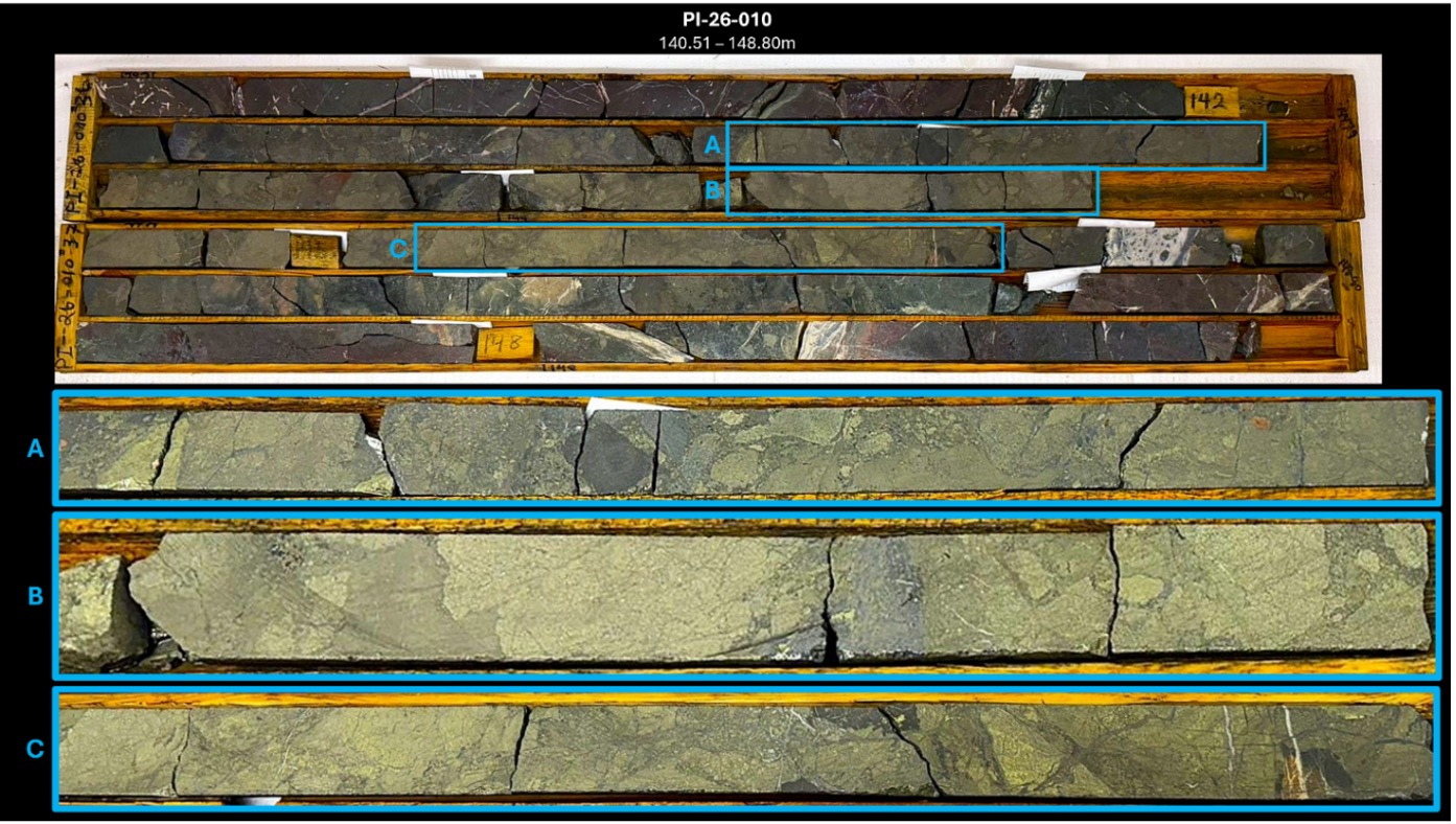 Figure 1: Drill core (lower zone) in hole PI-26-010 from 140.51 - 148.80m downhole. Detailed photo from core box, outlined in blue, highlighting sections of massive chalcopyrite + pyrite sulphide mineralization. See Table 2 for detailed visual descriptions. Highlights:
"Holes 9 and 10 have successfully intersected the newly discovered lower massive sulphide lens extending the zone approximately 40 metres to the northwest at a vertical depth of only ~135 metres," said Nick Rodway, CEO of HM Exploration. "These visual results continue to strengthen our geological model and reinforce the potential that we are vectoring toward the source of the mineralized system. With assays pending from all twelve Phase One drill holes, we are already planning a downhole EM survey followed by a Phase Two drilling program for fall 2026." The 2026 Phase One Drilling program was focused on evaluating the continuity of the mineralized system below known surface showings and along strike of the Clifford Jones Zone (the "Zone") to improve the Company's understanding of the geological controls on mineralization (Figure 4). Visual observations from drilled holes indicate that the upper targeted copper-bearing debris flow was successfully intersected, with zones of alteration and massive to semi-massive sulphide mineralization observed in the drill core. Drill holes 9 and 10 have successfully intersected a lower mineralized sulphide lens that was previously undiscovered. Core samples have been submitted to the laboratory for analysis. Assay results will be released once they have been returned to the Company. Holes 9 and 10 intersected a wide range of massive, semi-massive and disseminated sulphide mineralization over the following drill core lengths*:
Observations from drill core continue to support the interpretation that the new lower mineralized sulphide lens may represent debris deposited closer to the original hydrothermal vent system (Figure 5). Mineralization can be described as clast-dominated debris zones predominantly consisting of sub-angular to angular fragments of massive sulphide composed of Cpy + Py ± Sph ± Gn suspended in interstitial fine-grained disseminated sulphides (Py + Cpy ± Sph ± Gn) and milled felsic ± mafic rock. Matrix-dominated debris flow composed of fragments of sub-rounded to angular clasts of massive sulphide (Py + Cpy ± Sph ± Gn) and felsic ± mafic lithic fragments suspended in a matrix of fine-grained sulphide (Py + Cpy ± Sph ± Gn) and milled felsic ± mafic rock. More detailed classifications for individual intercepts are referenced in Table 2 below*. * The Company cautions that the presence of visible sulphides and visual estimates of mineral abundance are not indicative of grade and should not be considered a substitute for laboratory analysis. Assay results are pending. True widths of mineralized intersections are currently unknown. 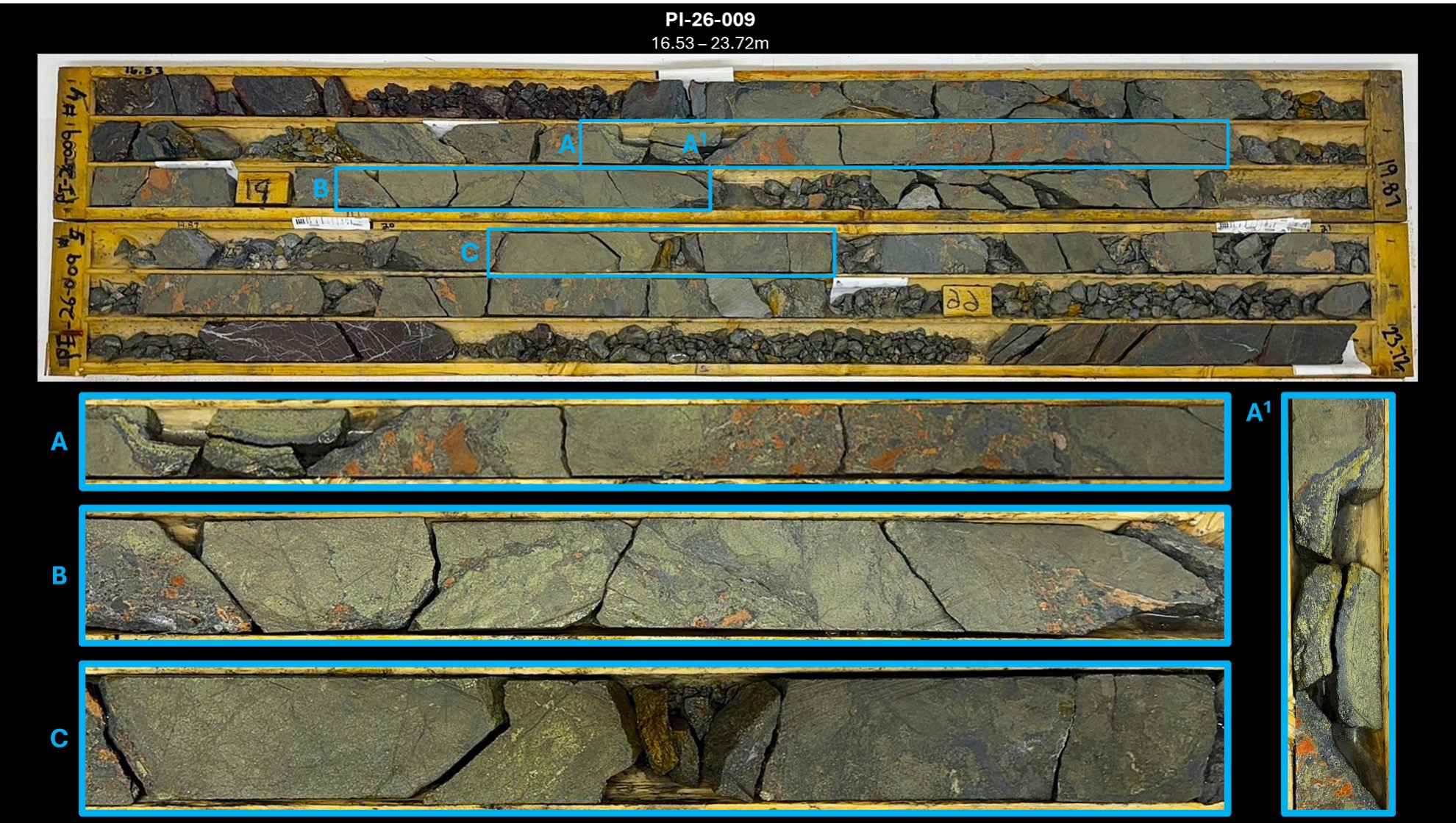 Figure 2: Drill core (upper zone) in hole PI-26-009 from 16.53 - 23.72m downhole. Detailed photo from core box, outlined in blue, highlighting sections of massive chalcopyrite + pyrite sulphide mineralization. See Table 2 for detailed visual descriptions. 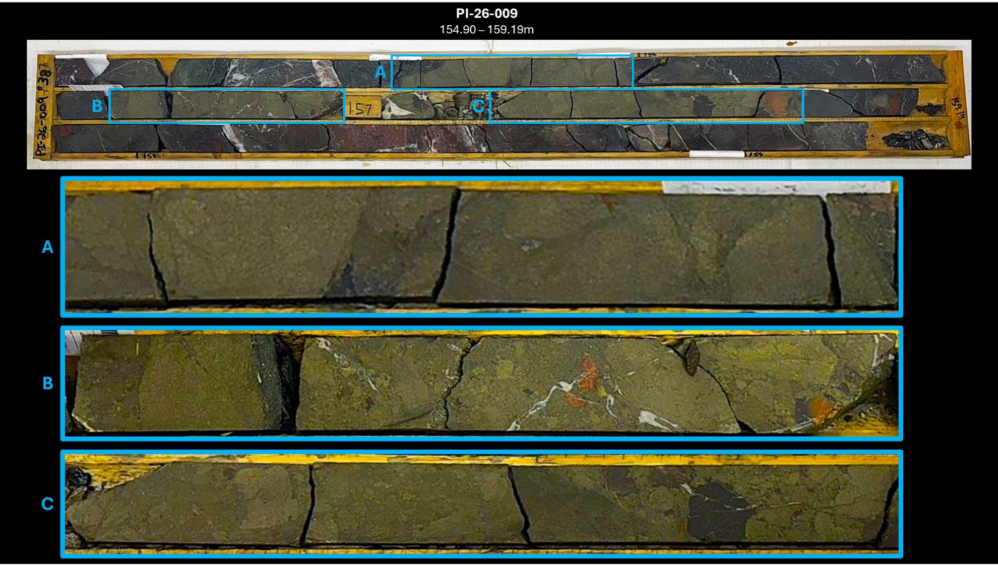 Figure 3: Drill core (lower zone) in hole PI-26-009 from 154.90 - 159.19m downhole. Detailed photo from core box, outlined in blue, highlighting sections of massive chalcopyrite + pyrite sulphide mineralization. See Table 2 for detailed visual descriptions. 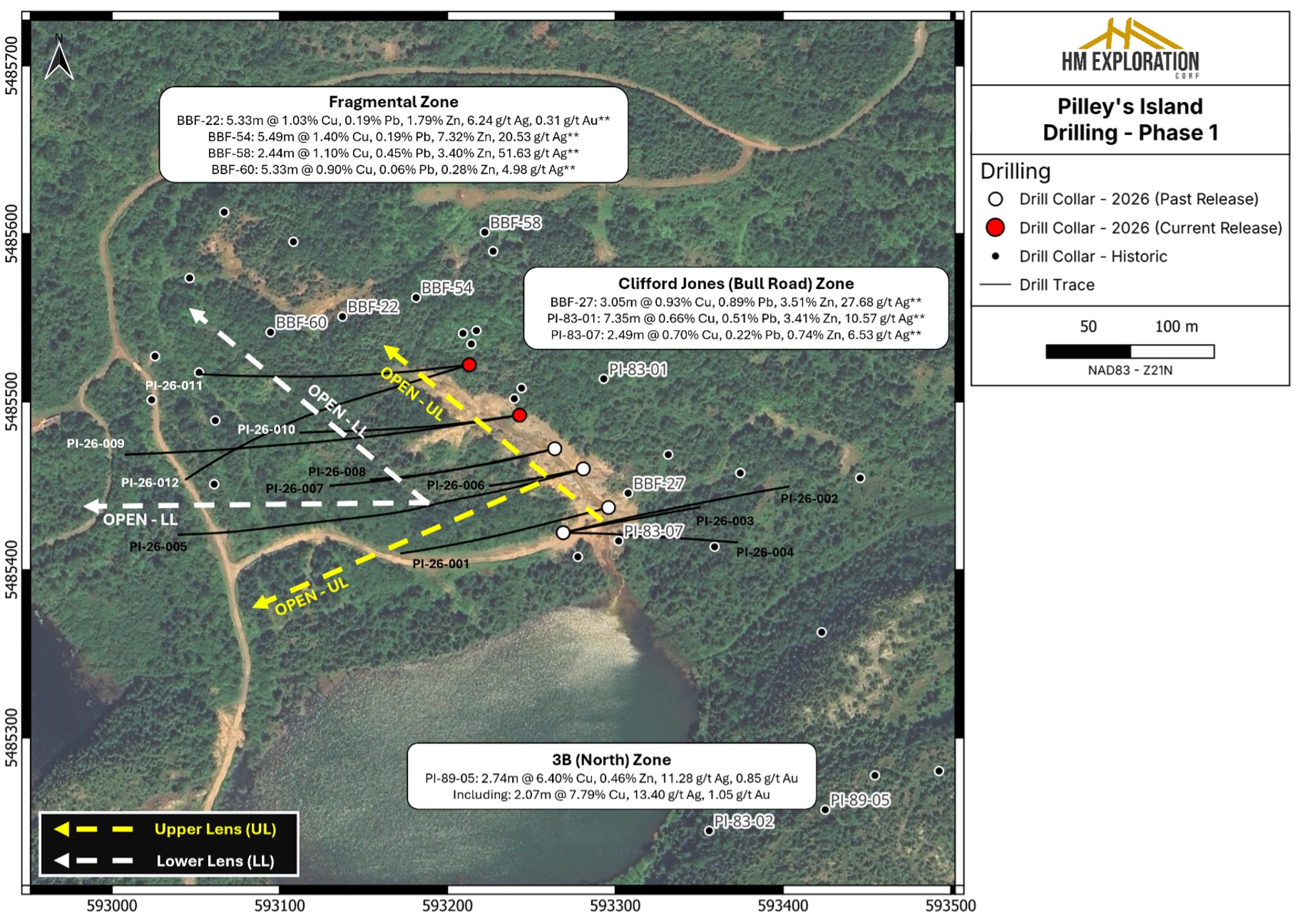 Figure 4: Plan map of 2026 diamond drilling at the Clifford Jones (Bull Road) Zone. ‘This Release' drill collars shown as red circles; ‘Past Release' drill collars shown as white circles; Historic drill collars shown as black circles. Currently the upper lens (UL) and lower lens (LL) mineralization remains open along strike and at depth. 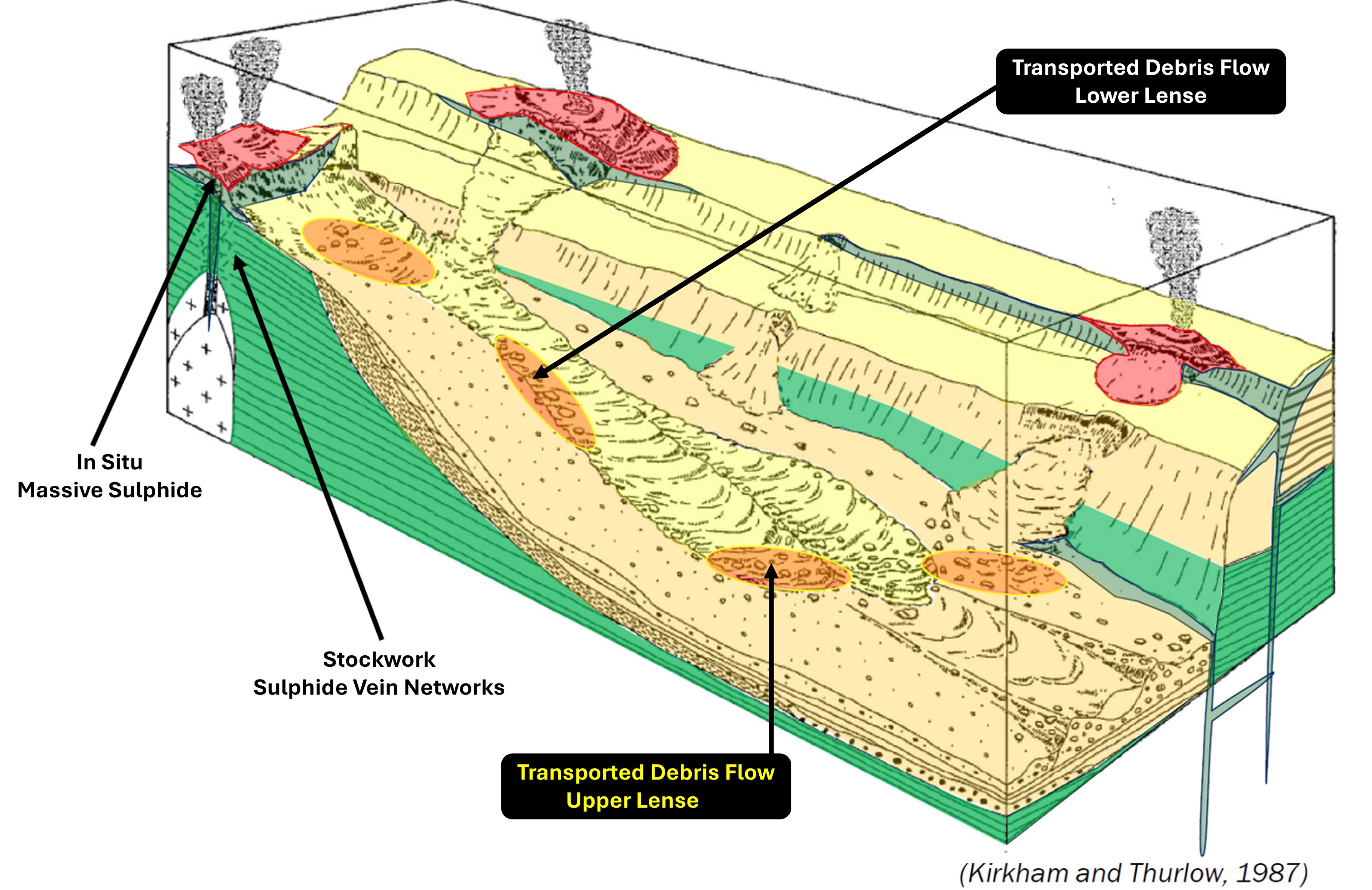 Figure 5: Conceptual model of VMS mineralization and the locations of where various types of mineralization may be located within the system. Mineralization intersected at the Clifford Jones Zone appears to be transported from source; however, the angularity of the massive-sulphide clasts may indicate limited transport distance from the source vent (Modified after Kirkham and Thurlow, 1987). Table 1: 2026 drill collar data; Coordinates reported in NAD83 - Zone 21N.
Table 2: Mineralized interval descriptions.
Geology & Mineralization The Project is located within the Notre Dame Subzone of the Dunnage Tectonostratigraphic Zone. Of note, most of the Project is underlain by Ordovician submarine volcanic rocks of the Roberts Arm Group which is regionally identified as part of a mature arc sequence referred to as the Buchans-Roberts Arm Belt that also hosts the historic Buchans mine (after Dunning et al., 1987). Mineralization occurs as lower grade (Spencer's Dock); medium grade (Old Mines); and high grade (3B-Zone/Clifford Jones) deposits that are of both sub-seafloor replacement and exhalative varieties. The deposits are often flanked by extensive chlorite, sericite, silica, K-feldspar and epidote alteration often observed in bimodal-felsic VMS systems. The Spencer's Dock area displays sericite/silica alteration that generally increases in intensity near mineralized zones, while the 3B/Old Mine areas display sericite/silica alteration that is abundant but less widespread and is more intense when proximal to mineralized zones (after Kerr, 1996). VMS deposits are a globally significant source of copper, zinc, lead, silver, and gold. The Project's geology shares key characteristics with known Volcanogenic Massive Sulphide ("VMS") districts in Newfoundland, including the past producing Buchans, Ming and Rambler Mines, supporting the exploration potential of the Project. About Lewis Pilley's Project The Project is road accessible and situated approximately twenty-five (25) km east of the town of Springdale, approximately fifty-five (55) km southeast of Firefly Metals' Green Bay Project and approximately one hundred fifty (150) km from the Pine Cove Mill and Port by way of major roads (Figure 6). The Project has a long history of mining and exploration dating back to the late 1800s when the Pilley's Island Pyrite Company Ltd. produced approximately 450,000 tonnes of massive pyritic ore from the Pilley's Island Mine-Old Mines (after Kerr, 1996). The Project hosts a cluster of VMS systems and prospects with demonstrated high-grade Zn-Pb-Cu-Ag+/-Au intersections. Mineralization is typical bimodal-felsic VMS, with both massive sulphide and sulphide-clast breccias (Thurlow, 1996). The geological setting is directly analogous to the Buchans camp (Thurlow, 1996), and the presence of sulphide-clast breccias is a strong vector toward proximal massive sulphide lenses. Most of the historic showings that fall within the extents of the Project have not seen systematic exploration. Many of the historic drill holes were shallow and drilled in a vertical orientation limiting the geological knowledge of the extents of the underlying lithology and mineralization. Work is being planned to validate historic assay results as well as collect new data from the 3B-Zone, Clifford Jones (Bull Road) Extension, Bouzanne Shaft, Henderson, Mansfield and Pilley's Cove Showings. 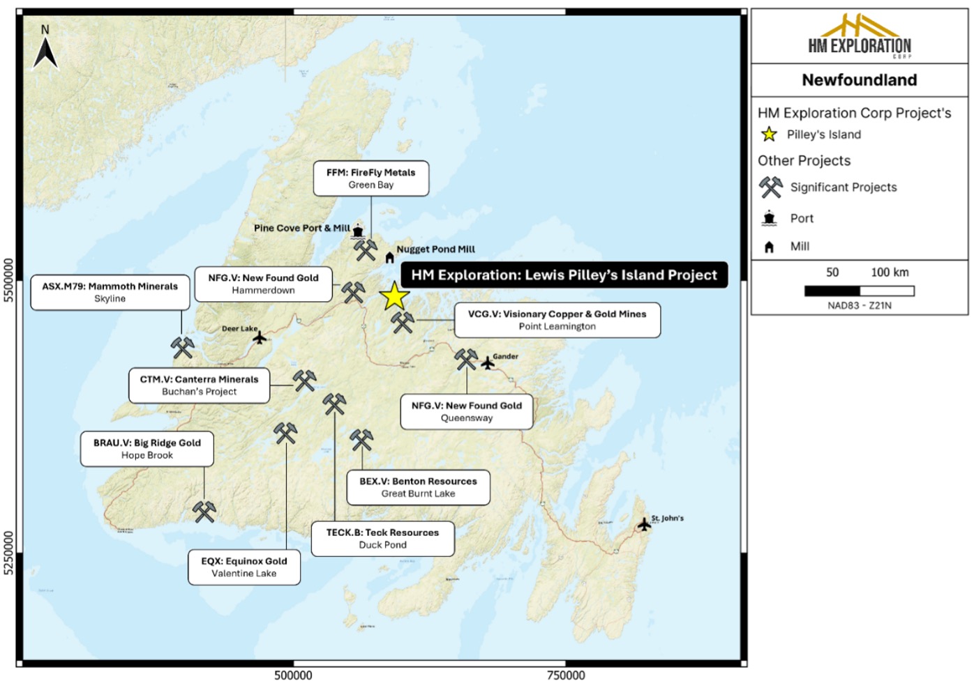 Figure 6: Regional map of Newfoundland displaying the location of the Project as well as other significant mineral exploration and mining projects in Newfoundland - Canada. Sampling, Preparation & QA/QC Drill collar locations were determined from hand-held GPS (NAD83-Zone 21N) and the drill rig was aligned using a Reflex TN-14 Gyrocompass alignment tool. All samples are given a unique sample ID and number and shipped directly to Eastern Analytical Ltd. (403 Little Bay Road, Springdale, NL), a commercial laboratory that is ISO/IEC 17025 accredited and completely independent of the company. Analytical methods include ICP-OES (34 element) with four-acid digestion, Au Fire Assay (30g) with AA finish, and Ore Grade Assay (multi-acid digestion) with AA finish. The Company inserts standard, blank, and duplicate samples as part of its standard QA/QC procedures. National Instrument 43-101 Disclosure Nicholas Rodway, P.Geo, (Licence# 46541) (Permit to Practice# 1000359) is CEO and Director of the Company, and a qualified person as defined by National Instrument 43-101- Standards of Disclosure for Mineral Projects. Mr. Rodway has supervised the preparation, verified and approved the technical content in this news release. Verification included review of drill logs, sample tags, chain of custody procedures and analytical protocols. No limitations were noted during the verification process. References Dunning, G.R., Kean, B.F., Thurlow, J.G and Swinden, H.S. (1987): Geochronology of the Buchans, Roberts Ar Source : Webdisclosure.com |
Cotations différées d'au moins 15 minutes (Paris, Amsterdam, Bruxelles, Lisbonne).
Cotations à la clôture (Francfort, New-York, Londres, Zurich).
Flux de cotations : Euronext (Places Euronext et Cours des Devises).
Bourse : technologie Cote Boursière